Round Rock is asking residents to help shape the future of one of the community’s most valuable assets: its trail system.
The City of Round Rock has launched an online survey as part of the ongoing update to its Citywide Trails Master Plan. The plan will help guide how the City’s trail system is planned, built and improved in the years ahead. The survey builds on input already gathered through in-person open houses late last year and gives residents another chance to weigh in online.
The City has already identified existing trails and potential future trail alignments through the planning process, so the intent of this survey is to collect feedback on how people currently use trails, how they want to use them in the future, what destinations they want trails to connect to, what makes them feel safe on trails and what trail characteristics matter most. Continuing to understand user preferences will allow the City to refine existing and potential future trail alignments. Any proposed trail concepts shown are conceptual and may change as planning and design continue.
In a 2024 community-wide survey, residents ranked hike and bike trails as one of the most important parks and recreation services the City should provide. At the same time, resident satisfaction with trails is moving in the right direction as new trail segments are completed, increasing seven percentage points since 2022.
A major element of the survey is the discussion of trail-oriented development (TrOD). As part of the master plan update, the City is reviewing best practices and developing a toolbox for trail-oriented development and placemaking, particularly along the Brushy Creek Trail. The survey defines trail-oriented development as a compact, mixed-use development approach that clusters residential and commercial uses around off-street trails and is intentionally oriented to trails and the people who use them. These strategies could be applied to specific trail segments in the future, including areas along Brushy Creek and near Downtown Round Rock, and the master plan will provide a high-level review of the policies and practices that can help the City and private development partners better leverage trails as a broader community asset.
The master plan update is considering not only where trails go, but how people experience them once they are there and how the system can feel more coherent. The planning process also includes a significant focus on signage to make the trail system easier to understand and use for all types of users. Along the Brushy Creek corridor in particular, signage improvements can help users understand the system, navigate decision points, identify trailheads, learn about amenities and feel more connected to the trail environment. Residents are asked which types of signage are most important for trails to include, including mile markers, directional signage, trail etiquette signage, trailhead signage and interpretive signage.
This outreach comes at a time when Round Rock has already made substantial investments in trails and connectivity. Round Rock has more than 20 miles of built hike and bike trails, with additional miles in planning, and the City is continuously working to link segments together for better connectivity.
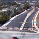
Heritage Trail West, completed in December 2024, added approximately one mile to the Brushy Creek Trail system. Heritage Trail East, which is still in the planning stages, will connect Mays Street to Georgetown Street through a future park on the banks of Brushy Creek and includes a planned pedestrian bridge across Brushy Creek that will connect the trail network into Downtown. Lake Creek Trail, also recently completed, is a 10-foot-wide path connecting Round Rock West Park to Centennial Plaza in Downtown Round Rock, including a crossing under Interstate 35. As Williamson County continues expanding the regional Brushy Creek Trail system and the City completes Heritage Trail East, the Brushy Creek corridor will form a continuous trail of more than 17 miles running across Round Rock from its west to east boundaries.
Residents can take the survey and learn more about the Trails Master Plan update at publicinput.com/rrtrailsplan.