The Historic Round Rock Collection
Historical Markers
The Historic Round Rock Collection is a project documenting Round Rock’s history, funded in part with a grant from the Texas Historical Commission. These pages are adapted from the original 1991 print version; later additions have been made by staff. Recent Round Rock news is given in the News feature.
There are many marked historical sites in and around Round Rock. Some have been designated as Texas Historic Landmarks and are on the National Register of Historic Places. Most of these properties display a National Register plaque, sometimes with explanatory text.
At this time Round Rock does not have an official plaque to indicate local designation, but a few properties have descriptive plaques provided by civic groups. Click image above to open a larger map. Additional information is available about some properties on the Historic Architecture page.
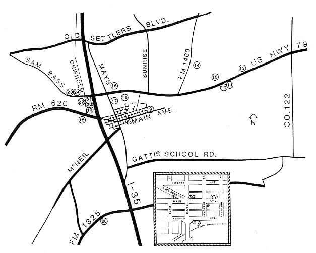
Legend | |
T | Texas Historical Marker with explanatory text Texas Historical Medallion (no text) Local Historical Marker with explanatory text |
| Key | Type | Site Name & Location |
|---|---|---|
| 1 | T | Andrew J. Palm House (Visitor Center/Chamber of Commerce) 212 E. Main Street |
| 2 | L | Dr. Dick Gregg Memorial 212 E. Main Street |
| 3 | T | J.A. Nelson Company 201 E. Main Street (Early Commercial Building) |
| 4 | T | Otto Reinke Building 102 E. Main Street |
| 5 | T | Old Broom Factory 100 E. Main Street (marker on the Mays side of the building) |
| 6 | T | Sam Bass Death Site In grass on the south side of Round Rock Avenue just west of Mays Street. The actual site of his death is directly across Round Rock Avenue. |
| 7 | L | Baylor Bus Crash Memorial Northeast corner or S. Mays Street and Bagdad Street. Erected by the State Highway Commission. |
| 8 | T | Nelson-Crier House 405 E. Main Street |
| 9 | T | Trinity Lutheran College 1000 E. Main Street (on the north side of the street, just east of College Street) |
| 10 | T | Kenney’s Fort South side of Palm Valley Road (US 79). |
| 11 | T | Double File Trail 2 miles east of Mays Street (US 81) on the south side of Palm Valley Blvd. (US 79) |
| 12 | T | Confederate Chaplains West of the entrance of Old Settler’s Park, 3 miles east of Mays Street (US 81) on the north side of Palm Valley Blvd. (US 79). |
| 13 | T | Palm Valley Lutheran Church 2500 Palm Valley Blvd |
| 14 | T | Anti-Slaveholding Union Baptist Cemetery 0.6 mile north of Palm Valley Blvd. (US 79) on the east side of FM 1460. |
| 15 | M | Washington Anderson House (El Milagro) Heritage Center Circle, off Palm Valley Blvd. (US 79), 0.2 mile east of Mays Street (US 81) |
| 16 | L | Texas Baptist Children’s Home Near the northeast corner of N. Mays (US 81) and Palm Valley Blvd. (US 79) |
| 17 | T | Pioneer Builders On the east side of N. Mays Street (US 81) just south of Palm Valley Blvd. (US 79) across from the entrance to the First United Methodist Church |
| 18 | T | Old Stagecoach Inn 901 Round Rock Avenue (marker missing) |
| 19 | M | Quick Residence 603 Chisholm Trail. |
| 20 | T | The Round Rock On the bridge over Brushy Creek on Chisholm Trail just north of Round Rock Avenue (RM 620). A local historical marker is nearby. |
| 21 | L | The City of Round Rock (Old Town) In the north side of the creekbed, just east of the Round Rock marker |
| 22 | T | William M. Owen House Complex (St. Charles Hotel) 8 Chisholm Trail |
| 23 | T | Round Rock Cemetery At the entrance of the cemetery on the north side of Sam Bass Road, 0.5 mile west of IH-35. Slave Burial Ground Marker is also located here. |
| 24 | T | Slave Burial Ground Mid-way along the west border of Round Rock Cemetery on the north side of Sam Bass Road, 0.5 mile west of IH-35. Round Rock Cemetery marker is also located here. |
| 25 | T | Bratton Cemetery On the south side of West Louis Henna Blvd., 0.6 mile west of IH-35 |